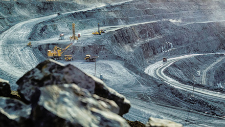
Mapping soil moisture for coal tip safety
An extensive satellite mapping project is starting to assess colliery spoil tips in South Wales.

Central Alliance, part of the RSK group of companies, has been commissioned by the Coal Authority through a Welsh Government grant scheme to undertake the project. This work is upholding the Welsh Government’s commitment to proactive assessment of climate change.
The project, which will utilise GroundSat, a newly developed soil moisture mapping technique, is part of the Coal Tips Safety programme. High-resolution soil moisture data and analysis will be carried out over tips and surrounding areas across 10 different local authorities in South Wales. The assessment will confirm the effectiveness of existing drainage systems and identify any hidden moisture which could represent a future risk.
GroundSat, which uses L-Band Synthetic Aperture Radar. The technology is an adaptation of space technology used to search for water on other planets. It allows users to remotely measure soil moisture levels below ground level, assessing sites and identifying geotechnical risks or drainage issues before they have an impact on critical infrastructure, construction projects and development sites.
Lori Frater, the Welsh Government’s Head of Coal Tip Safety Task Force says, ‘Alongside engineering works, technology has an important role to play in ensuring the safety of disused coal tips. It’s important that all possible means of monitoring of tips over the long-term are considered and funding different technology trials helps to ensure we have appropriate approaches in place.’
The project is due to start this month, capturing data in relatively drier months, with a second phase to capture seasonal change in winter introduced early next year.