Could the Brazilian dam collapse have been predicted with satellite radar imaging?
One of Brazil’s worst environmental disasters - a dam collapse that also killed more than 200 people - could have been foreseen with the right monitoring technology.
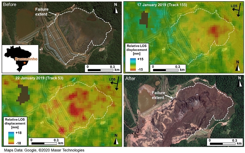
Top left and the bottom right are satellite images of the Brumadinho tailings dam taken before and after the collapse on 25 January 2019. Top right and bottom left show precursory movement across the dam (red and yellow colours), which the researchers analysed to find that the collapse could have been predicted
© 2020 Maxar TechnologiesAccording to a new study by the University of Nottingham and Durham University, UK the disaster could have been foreseen. The high-profile catastrophe took place on 25 January 2019 at a tailings dam near the Córrego do Feijão iron ore mine, close to the town of Brumadinho, in the Minas Gerais state in south-east Brazil.Owned by Vale, Brazil's largest mining company, the tailings dam was used for more than 40 years to hold waste from the mine. There are growing concerns about the stability of this particular type of dam and a significant number need enhanced monitoring, says lead author Assistant Professor Stephen Grebby from the Nottingham Geospatial Institute at the University.
Applying InSAR (satellite radar imaging) to check for small ground movements in and around dams is not current standard practice and this is something Grebby would like to see change.
Grebby says, 'Most mining companies currently rely upon ground-based sensors to monitor the stability of dams. However, these typically offer an inadequate coverage of measurements over the whole of the dam, which can make it difficult to detect movement or other signs of distress.'
He collaborated with Durham University and University of Nottingham spin-out company Terra Motion Ltd on the study to identify whether failure at Brumadinho could have been foreseen.
They used an advanced InSAR technique called Intermittent Small Baseline Subset (ISBAS), developed by the University of Nottingham and Terra Motion, which can help overcome the limitations faced when using some of the more conventional InSAR techniques over vegetated terrain. Another benefit of this technology, over on-the-ground sensors, is it looks down from above and offers a more complete picture of ground movements with millimetre-level accuracy.
Dr Grebby adds, 'Our ISBAS InSAR results revealed that different areas of the dam were moving at different rates and some of these were seen to accelerate suddenly during the two months preceding the collapse. Despite the dam being monitored by the mining company using standard techniques with no apparent warning raised, our analyses of the precursory movement indicate the timing of the collapse was foreseeable.
'If monitored routinely, using the ISBAS InSAR technique, the failure date could have been predicted to within a week of it happening. Crucially, this prediction would have been possible around 40 days prior to the collapse, allowing time for a warning to be raised that the dam was becoming unstable. This could have led to more in-depth monitoring or other mitigation measures to avert the loss of life and environmental disaster that tragically unfolded.'
The researchers are now looking to develop the technology as a software that could be offered to the mining industry, which is looking out for a reliable, early warning system to predict the risk of imminent collapse at tailing dams. Combined with on-the-ground sensors, Grebby sees advanced InSAR techniques as a valuable addition to the monitoring tool box to evacuate and protect life.